
Apparently the best way to browse the 551 items in the Indiana Historical Society's Northwest Territory collection is to go to their main web site, click on collections, and from the drop-down menu pick "digital image collections." On that page, click on the link in the sentence "You can search across all collections here."
Then select "Northwest Territory Collection, 1791-1825" and click add. If you want to browse, type "northwest" in the top bar of the search and your result will be 551 documents with tidy descriptions off to the right. There's a lot of military stuff, because the resident Indian tribes were not yet willing to give up their land.
There's also useful information if you're a Vertner or Kilgore researcher in the area: an order from a not clearly identified court for the sheriff of Ross County in the Ohio territory to seize "Nathan" (I read the name as Mathew) Kilgore's goods in order to collect a debt he owed Daniel Vertner, originally of $47 but now with interest and court costs ballooned to $65.
(You won't find these people in the census. There's little useful census information in Ohio for another twenty years.)
There doesn't seem to be a lot of context here, and I looked in vain for an overall description of the collection, or why it is labeled as it is, since it contains at least one document from 1764. More diligent visitors should feel free to enlighten me in the comments!
Hat tip to Region Roots from the Lake County (IN) Public Library.
Wednesday, October 6, 2010
Northwest Territory papers on line
Save And Share :


![]()
![]()
Tuesday, May 27, 2008
Historical Maps Online
"The intent of the Historical Maps Online project is to electronically publish the images of maps charting the last 400 years of historical development in Illinois and the Northwest Territory." That's the first line on the website, which is a collaborative project of the University of Illinois Library and the University of Illinois Press, with help from other outfits including the Newberry Library.
The site's search function is odd, such that "Edwards County" with or without quotes brings up 213 hits, most of them irrelevant, whereas "Edwards" alone brings up 4, including the relevant county page from Warner and Beers' 1876 atlas of the state. These atlas pages are the most obviously genealogically useful ones -- with old towns and all townships delineated for each county -- but they can't be enlarged as much as one would like.
Browsing categories for this collection are topographic maps of Illinois (290), North America (89), Northwestern Territory (11), former colonies in North America (1), Louisiana Territory (14), Canada (Nouvelle France) (9), early maps (49), South America (111), Mexico (6), Illinois (756), Indiana (32), Champaign County (749), Indians of North America (769), Warner and Beers Atlas 1876 (286), and maps from the Newberry Library (9). Thanks to Diane Walsh on the St. Clair County mailing list for pointing this out.
Save And Share :
![]()
![]()
Thursday, March 6, 2008
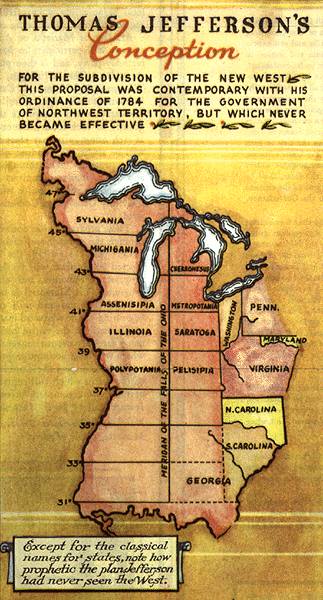
The Midwest as it might have been
I write to you from near the boundary of Assenisipia and Metropotamia...
Check out Thomas Jefferson's version of the Northwest Territory at Strange Maps. (Hat tip to Sam Smith for the pointer.)
Here's how it really happened, plus a slightly different version of Jefferson's map, all on John Lindquist's awesomely well-documented site. Looks like this is the one to bookmark, but also check out Illinois Trails, which has a number of early Northwest Territory maps, plus some genealogical leads if you have research targets that early in this part of the world.
Save And Share :
![]()
![]()
