
 You didn't want to get anything done today, anyway! Good and potentially good things (I haven't looked at them all yet), moving from west to east . . .
* Chicago in Maps, cartographer Dennis McClendon's on-line collection of Chicago maps from 1834 to 2014.
* M. Susan Murnane's new book, Bankruptcy in an Industrial Society: A History of the Bankruptcy Court for the Northern District of Ohio (Akron: University of Akron Press, 2014), said to be "a social and institutional history of the Bankruptcy Court for the
Northern District of Ohio. The work explains the development of the
court and the story of the people who worked there and of those who
sought refuge in the bankruptcy court, within the context of northern
Ohio's changing economy."
* Friend and colleague Amy E. K. Arner's new book, Abstracts of Westmoreland County, Pennsylvania, Tax Records 1815 (Berwyn Heights, MD: Heritage Books, 2014).
* Not new at all: Historian Thomas Bender's Community and Social Change in America (New Brunswick, NJ: Rutgers University Press, 1978): "There were apparently two populations in nineteenth-century towns, an economically successful permanent group who shaped the values and direction of social life in the town, and a floating, largely unsuccessful group. We know little about those who left nineteenth-century towns." By contrast, in his view, "in contemporary America, men and women do not so much move from one town to another as follow an advantageous career path that may take them to a number of basically incidental locations." {93} Now the successful are the floaters?!
Harold Henderson, "A Genealogy Christmas . . . ," Midwestern Microhistory: A Genealogy Blog, posted 14 December 2014 (http://midwesternmicrohistory.blogspot.com : viewed [date]). [Please feel free to link to the specific post if you prefer.]
Sunday, December 14, 2014
A Genealogy Christmas . . .
Save And Share :


![]()
![]()
Friday, May 16, 2014
Illinois Civil War, Kalamazoo, Route 66, and more -- what's not to like?
Has anybody out there still not subscribed to the smart, knowledgeable, uncluttered weekly collection of links from the University of Wisconsin's Internet Scout Report?
If so, this would be a good week to take a look. It's almost as if Midwestern Microhistory had a secret agent there! Starting at the center of this blog's geographic interest and working out:
Digitized Civil War letters from Illinois (Northern Illinois University)
Photos from Kalamazoo College (Kalamazoo College)
Oral histories of Route 66 in Missouri (Missouri State University)
Central Pennsylvania landscape, landscape architecture, and architecture (Penn State University)
Old New Hampshire maps and atlases (University of New Hampshire)
Archive of Early American Images, 1600s-early 1800s (Brown University)
Even when we want to, it's not always easy for genealogists to find their way to the resources of academia. This outlet -- either as weekly newsletter or as web site -- is worth the time for that reason alone.
Harold Henderson, "Illinois Civil War, Kalamazoo, Route 66, and more -- what's not to like?," Midwestern Microhistory: A Genealogy Blog, posted 16 May 2014 (http://midwesternmicrohistory.blogspot.com : viewed [date]). [Please feel free to link to the specific post if you prefer.]
Save And Share :
![]()
![]()
Monday, March 10, 2014
Methodology Monday in NGSQ: Tracking Tatums
Pamela Strother Downs serves up a Southern-style methodology treat in the current issue of the NGS Quarterly. Carefully proceeding from a man who died in Louisiana back to Alabama and Georgia, she extends a Tatum line two generations downstream from where they were accounted for in John Frederick Dorman's Adventurers of Purse and Person.
As often in the Q, the map and the table accompanying the article are not just ornamental, and they repay careful study.
The map: Census records list two landless people in Montgomery County, Alabama, in 1830 as being 28 pages apart. Downs located landowner neighbors and mapped their locations. Without locating just where the landless pair lived in 1830, the map shows that they had to live nearby because their landed neighbors did. This was a key piece of evidence in completing the lineage, and it's a key technique to use and reuse in Dark Age US research, wherever your people may be.
The table paired two timelines of same-name Tatum men to show that an earlier DAR application confused one with the other.
Tatum researchers will appreciate the two extra generations; we all can appreciate seeing good technique in action.
Pamela Strother Downs, "Ancestry of Henry Tatum of Alabama, Georgia, and Louisiana: Migration and Mistaken Identity," National Genealogical Society Quarterly 101 (December 2013): 273-90.
Harold Henderson, "Methodology Monday: Tracking Tatums," Midwestern Microhistory: A Genealogy Blog, posted 10 March 2014 (http://midwesternmicrohistory.blogspot.com : viewed [date]). [Please feel free to link to the specific post if you prefer.]
Save And Share :
![]()
![]()
Wednesday, November 7, 2012
Kosciusko County and Many Other Maps On Line
Dick Eastman broadcast a nice local digital newspaper story about the Kosciusko County, Indiana, Historical Society placing grave listings and photographs on line as part of the county's GIS mapping system for properties.
But there's more to the story: The web site is part of a multi-county service called Beacon: Local Government GIS for the Web. Kosciusko and 26 other Indiana counties also have multi-purpose zoomable GIS maps and searchable information on current properties under this format. Four counties in Illinois (Cass, Morgan, Ogle, and Whiteside), one in Michigan (Berrien), and several in Alabama, Arkansas, Kansas, Minnesota, Missouri, South Carolina, and South Dakota also have this feature. So far as I've been able to tell, Kosciusko is the only place going the extra mile with the cemetery database and images bonus. (So it is now possible to cross-check these against other on-line listings such as Find a Grave, as well as non-digital published readings.)
Just click on the "All States" drop-down menu and pick your favorite state and county (if available) and spend some time with the maps. They don't have all the features genealogists would want by any means, but they have a lot.
Harold Henderson, "Kosciusko County and Many Other Maps On Line," Midwestern Microhistory: A Genealogy Blog, posted 7 November 2012 (http://midwesternmicrohistory.blogspot.com : accessed [access date]). [Please feel free to link to the specific post if you prefer.]
Save And Share :
![]()
![]()
Thursday, October 25, 2012
The Right Map for the Road Trip

Yesterday I was grateful to have brought along a must-have for anyone planning to work on tax lists or property records (I had both): a good map of the subdivisions of the county I was working on, which in the case of Michigan means a township map. And Michigan has a lovely one; I wish every state did it this well. Unless you know by heart the township and range of every township in your federal-land county, you need it too. How else will you realize (for instance) that the 1875 tax list is organized by township, not alphabetically but in order from the southeast corner to the northwest corner?!
Actually I could have used one other thing -- a list of all the former names of townships. But since only one or two had changed, there was a workaround.
Harold Henderson, "The Right Map for the Road Trip," Midwestern Microhistory: A Genealogy Blog, posted 25 October 2012 (http://midwesternmicrohistory.blogspot.com : accessed [access date]). [Please feel free to link to the specific post if you prefer.]
Save And Share :
![]()
![]()
Sunday, September 30, 2012
The Top Five MWM Posts for August 2012
Once again it's time for the monthly popularity contest, listing the most-viewed blog
posts made during August. Once again, #1 was far in the lead. I'll report on September
in early November when the dust of that month will have settled.
1. Eight Tips for Those Considering Certification (August 15)
2. Is an Obituary an Original Source? Does It Matter? (August 2)
3. Writing: The Ten Suggestions (August 7)
4. Book Review: How History and Genealogy Fit -- or Not (August 24)
5. Why Ambitious Genealogists Need Credentials (August 14)
Least viewed:
Halfway home: map of the 46 Indiana counties with marriages indexed on FamilySearch (August 25)
Harold Henderson, "Top Five MWM Posts for August 2012," Midwestern Microhistory: A Genealogy Blog, posted 30 September 2012 (http://midwesternmicrohistory.blogspot.com : accessed [access date]). [Please feel free to link to the specific post if you prefer.]
Save And Share :
![]()
![]()
Saturday, August 25, 2012
Halfway home: map of the 46 Indiana counties with marriages indexed on FamilySearch

Volunteer to help index: even on line, just spending time with original records is a learning experience.
Harold Henderson, "Halfway home: map of the 46 Indiana counties with marriages indexed on FamilySearch," Midwestern Microhistory: A Genealogy Blog, posted 25 August 2012 (http://midwesternmicrohistory.blogspot.com : accessed [access date]). [Please feel free to link to the specific post if you prefer.]
Save And Share :
![]()
![]()
Tuesday, May 31, 2011
Maps without copyright
For those who worry about copyright issues with the many wonderful maps available on the internet, I know of two good recourses that do not involve delving into the arcana of either the general rules on fair use of maps or a particular source's claims of rights. These are maps produced by the federal government, making good use of our tax dollars:
the National Atlas, and especially the mapmaker part, which deserves an extended discussion in itself but won't get it here; and
the Census Bureau, which has individual state maps of counties in outline, as well as a map of the whole country with counties in outline. That last comes in especially handy when your research targets thoughtfully lived next to the state line. (Thanks to Kathy Lenerz.)
Just because these are not copyrighted does not mean you can claim you made them yourself! Stay calm and cite your source.
Save And Share :
![]()
![]()
Friday, August 6, 2010
The Midwest in 1858
ResearchBuzz just made note of some new maps on the David Rumsey Map Collection, which provoked me to look around there. I was especially struck by the regional maps with counties and railroads from an 1858 atlas.
Just go to the Rumsey site and type in "Colton 1858 [your state name here]" minus the quotes and the brackets. I love the unformed counties, but especially the sparseness of the railroad lines. You can see where it would have been comparatively easy for your ancestors to travel, assuming they had the cash and a schedule!
Save And Share :
![]()
![]()
Sunday, September 6, 2009
Partial Saturday in Little Rock -- sign a petition for the Library of Michigan!
I had to leave early on the last day of the FGS conference, but did pick up a few thoughts:
* Got an ancestor in the 1830 census and no idea where he or she lived, because the county wasn't yet divided into townships? As part of the discussion of her "sure-fire never-fail" "5-P test for proving identity," Elizabeth Shown Mills gave a whirlwind demonstration of how to use census neighbors' landholdings to track the path of the census taker and thus locate individuals who hadn't purchased land.
* Paula Stuart Warren went through at least 20 different kinds of school records (I lost count) and almost as many different places to find them.
* Richard Sayre gave the nuts and bolts of topographic maps and the relevant coordinate systems. This seems to have been map day, because he too wound up showing how to correlate a variety of maps to find the exact present-day location of an ancestral farm, using online sources.
I was especially disappointed to miss Tom Jones on "Solving Problems with Original Sources," including such rarely consulted sources as Revolutionary War pension final payment vouchers, Federal district court papers, and "loose" probate papers (that is, the evidence and forms filed in the case, as opposed to the matter copied and preserved in will and probate record books). Fortunately, this session, like most, was to be recorded on CD by Jamb Tapes, Inc. of St. Louis and hopefully will soon be available via their web site. Their people had a several-times-daily aerobic workout coordinating the recording of speakers at far opposite ends of the Peabody Hotel and Statehouse Convention Center complex.
State-level news: Illinois has started planning for hosting the 2011 FGS in Springfield. And the joint FGS-NGS Records Preservation and Access Committee has started an on-line petition to save the Library of Michigan. The legislature can still reject the governor's ill-advised executive order that would disperse the library's collections; so far only one house has acted.
Save And Share :
![]()
![]()
Tuesday, June 2, 2009
"Sanborns" in Chicago
Last week I had a good three-stage learning process at the Chicago History Museum's Research Center [formerly the Chicago Historical Society's library] about what detailed fire-insurance-type maps (AKA "Sanborns") are available and where. Do note CHMRC's hours (not extensive) and admission fee ($5 a day or $15 a year).
First, I was introduced to a 1916 map -- black and white, copied from microfilm -- available on computers there and useful for orientation.
Second, there is Robinson's Atlas of the City of Chicago, Illinois, from 1886, which has been republished in full, free and online, in the Encyclopedia of Chicago. This is not the most user-friendly interface but it's manageable. Use the little slider bar verrry carefully.
Start with the Atlas Map close to the extreme left end. Magnify that map (you'll want to magnify everything) to ascertain which section, township, and range of the 1886 city includes your address. (Mine was Section 7, Township 39, Range 11, AKA 7-39-11, lying south of Chicago, north of Madison, east of Western, and west of Ashland, AKA 0 to 1200 North and 1600 to 2400 West in today's numbering scheme, which was not in use in 1886 but it helps to know it.)
Then return to the slider bar and slide it along until you get to the volume associated with your desired neighborhood or address. (Mine was volume 4.) At this point you may find that for no particular reason the map has rotated 90 degrees so that the east-west streets are going up and down. Use the rotator function to get the city headed in the right direction for a change. Then magnify magnify magnify and find the large-type plate number for your subarea. (Mine was 19.)
Continue along the slider to your desired plate number and magnify it as far as you can to see your chosen neighborhood, building by building.
Third, having done this, you can tell plenty but not as much as a full-dress fire insurance map can tell you. For that, visit CHM in person and use their on-table looseleaf binder of indexes to figure out which of their hard-copy atlases are available for which areas and which dates. (Not all areas and dates are covered by a long shot, but most areas seem to get some coverage for at least one date.) These are full-color, with notations on the type of roofing, the size of the water mains, the nature of construction (wood, brick, stone), the number of stories, and on and on. (EOC also has a nice short article by Richard Harris on some more sophisticated ways to "read" the maps.)
If you're the kind that wants icing on your cake, review the looseleaf binder again and then ask for the file folders of readily available images sorted by street name, church name, etc., in hopes of getting a ground-level view of your neighborhood back in the day. I didn't luck out but it's well worth trying.
Save And Share :
![]()
![]()
Wednesday, May 20, 2009
SBAGS April Quarterly
The South Bend Area Genealogical Society's quarterly leads off with accounts of the first three programs of the year: veterinarian and sometime national speaker Mike Lacopo in January on research ("reconstruct the entire family unit"), Gary Gabrich in February on Hungarian immigrants (the Magyar Haz in South Bend was in 1911 "the largest Hungarian cultural house in the entire United States"), and Jeff Bockman at the March Michiana Genealogy Fair on two topics: researching with maps, and researching without birth certificates.
Oh yes, and there are articles too:
Ken Reising on "The Mishawaka Fire of 1872"
Toni Cook on "Photos of Phoebe Ward Dunnahoo Cemetery Located" -- photos from 1940 taken shortly before the small family cemetery was relocated.
Save And Share :
![]()
![]()
Tuesday, May 19, 2009
Sanborn fire insurance maps on line
If you don't have access to a university library, you won't find too many of these fanatically detailed and carefully coded building-by-building Sanborn city maps on line. There are a few exceptions that I know of (anyone able to add more to the pot?):
INDIANAPOLIS: the IUPUI collection has selected years starting in 1887.
KANSAS CITY, MISSOURI: at the Kansas City Public Library's historical collection. They list some additional states with on line access to the public.
MISSOURI: 390 communities via the University of Missouri digital library!
LINCOLN AND MARATHON COUNTIES, WISCONSIN: 54 pieces of maps near railroad lines, part of the Central Wisconsin Digitization Project.
Most of the time, most researchers who recognize the extreme value of these beauties will have to proceed the old-fashioned way and get themselves to a good library.
UPDATE: The Newberry Library blog has posted numerous online links for these maps!
Save And Share :
![]()
![]()
Thursday, April 2, 2009
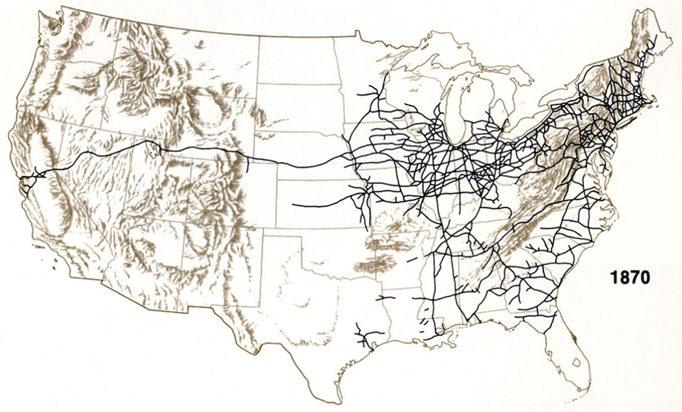
Getting There in 1848 and 1870
"Did Railroads Induce or Follow Economic Growth? Urbanization and Population Growth in the American Midwest 1850-1860" (PDF, National Bureau of Economic Research) Four economists have researched the effect of railroad development on Midwestern settlement between 1850 and 1860. If you're like me, you'll read the introduction and the historical information about how fast the new transportation mode developed (and how Ohio tried to quash it to protect the state's investment in canals!), skip most of the technical part, and check out the conclusions. It turns out that (if I have got it right) railroads didn't speed up settlement, but they did speed up urbanization. Not surprising given that they can't stop everywhere and therefore are a centralizing technology.
And then you'll discover that they footnote some very interesting old railroad and ship travel guides. (In order to measure the effect of railroads, they had to know exactly where they were when.) The links didn't all work for me. These are the ones I found, either directly or after a little fooling around, and I'm pretty sure there are more. These are extremely cool resources if you have folks migrating to or through the Old Northwest in this era:
Appletons' Railroad and Steamboat Companion, 1848 (Google Book Search)
1870 railroad map, not sourced
Travelers' Official Guide of the Railways and Steam Navigation Lines of the United States & Canada, June 1870. Note the prematurely psychedelic cover typography and the long list of local times.
Grain Dealers' and Shippers' Gazetteer, evidently 1891 (as digitized by Pam Rietsch), accessible one railroad line at a time. The maps are awesome; the gazetteer part contains names as well.
For further searching, check out the University of Texas's justly famous Perry-Castaneda Map Collection (no tilde available on blogger?).
Save And Share :
![]()
![]()
Friday, February 27, 2009
Blogs, Maps, and Forgotten Bookmarks in South Bend
FYI, the St. Joseph County Public Library's Family and Local History Section has had its own newsletter (PDF) for the last few months. In addition to their catalog, they have on line listings of genealogically useful holdings, including their maps (anyone for an 1838 street map of South Bend?) and research guides for those seeing Eastern European or Irish homelands.
The library also has an online database of locally published obituaries from 1913 to the present of people with ties to St. Joseph County, Indiana. (Print indexes of earlier obituaries are available.)
And that's not all, folks! One of the spookiest blog posts I've seen in a while was on the library's main SJCPL blog last month, featuring a bookmark from 1960 that turned up in a library book. Of course it's been entered as well on the web site (you knew there was one) called Forgotten Bookmarks. Yes, history can jump out and bite you!
Save And Share :
![]()
![]()
Wednesday, February 11, 2009
Fun with county maps
Thanks to SLIG classmate Jerry Edwards for reminding me of the animated historic county maps feature at FamilyHistory101. The Atlas of Historic County Boundaries it ain't, but it's fun to watch and fool around with.
Save And Share :
![]()
![]()
Wednesday, February 4, 2009
Illinois Civil and Congressional Township Maps
Woops -- I should have posted on this months ago. (Hat tip to Melissa Barker in the Transitional Genealogists forum for getting the ball rolling about maps the other day.) There's a central although well-hidden on line resource for maps of each Illinois county showing townships. If you're visiting in person, you have a good chance of finding such a map at the courthouse or library, one that will also include roads and landmarks, as I did in northwestern Illinois' Whiteside County last fall. If you're visiting virtually, you can get there in six easy steps:
(1) Visit the Illinois State Archives regional depositories page, maintained by the office of Illinois Secretary of State Jesse White.
(2) On the left-hand menu, click on the second tab down for "IRAD region map."
(3) That will bring up a colorful map of Illinois divided into seven regions, each festooned with the initials of the depository university. Click on your region of choice.
(4) That will bring up a close-up map of the region and its counties. Click on your county of choice.
(5) That will bring up a "_____ County Fact Sheet." Enjoy the facts; don't get too focused; but then scroll down a few screens to a thumbnail outline map of the county with subdivisions, which are the townships. (Hey, it's a big thumbnail.)
(6) Click on the thumbnail and presto, you have a printable map of the county and its townships. And when I say townships, I mean BOTH KINDS, the civil townships (with names you are or soon will become familiar with) and the congressional townships, with names like T36N R5E in La Salle County, which due to rivers that disobey the rectangular survey system, is not quite the same as the civil township of Northville.
Save And Share :
![]()
![]()
Friday, January 30, 2009
Did Your Ancestor Own Land in Illinois After 1859?
If so , you may be in luck. The Illinois State Library has a fine collection of land ownership maps and atlases, the oldest of which cover Hancock, Stephenson, and Winnebago counties in 1859. These were commercial products and coverage is uneven both as to counties and specific dates.
No, they're not on line; what makes this collection special is that most of it circulates via interlibrary loan. The full checklist of maps is on line (PDF); talk to your local librarian. Just one example: these maps can be used to generate a list of nearby neighbors if you trying to identify a woman's maiden name (even better if you can correlate them with a near-time census listing, not forgetting Illinois' state censuses on the 5's).
(Hat tip to Cyndi's List.)
Save And Share :
![]()
![]()
Wednesday, December 31, 2008
Brown County, Wisconsin, and its neighbors
As far as I can tell, the Wisconsin Digital Collections are just too big to understand in one gulp. Today I'm intrigued by the "subcollection" called "Brown, Door, Kewaunee, Oconto, and Shawano Counties: Historical Atlases, Directories, Plat Maps, and High School Yearbooks." The coverage area is basically the great cheesehead town of Green Bay and the counties north and east of it.
At first I was disappointed, as the yearbooks didn't seem to be browseable. But if you do a full-text search of the entire 86-volume subcollection, you can then browse throughout whichever yearbooks where you happen to have a hit. (The Okato for 20 December 1922 includes a receipts-and-expenditures statement for the preceding football season, itemized game by game, naming referees, umpires, and suppliers. Can you imagine?)
Naturally my fave is the 1874 Green Bay and Fort Howard Directory, compiled and arranged by (I swear it's true) J. Alfred Dull. The school yearbooks and newspapers are from the 1909-1929 time period. Brown County has four years' atlases, the earliest being an 1889 plat book. Door County has four atlases 1899-1923, the earliest including a directory of landowners by township. Kewaunee and Shawano each have two atlases. Don't you wish every state was like Wisconsin?
Save And Share :
![]()
![]()
Tuesday, December 23, 2008
Online resources at both ends of Indiana
In northern Indiana:
In Elkhart County, the Wakarusa Public Library Historical Room has a few photographs, maps, books, and articles on line, plus a goodly number of obituaries including full transcribed text from local newspapers. (I can't tell how many are indexed, but just two of them have birthdates before 1800.) The other items are browseable as well as searchable, the obituaries are only searchable. We all buzz right over to the obituaries, but if you have research targets there don't forget to check out the three plat maps of land ownership in Olive Township (the east half of congressional township 36 North range 4 East of the 2nd principal meridian) for 1874, 1892, and 1915.
Just a few miles south of Wakarusa near the Kosciusko county line, the Nappanee Public Library’s Evelyn Lehman Culp Heritage Center Collection has a similarly searchable set of obituaries.
In southern Indiana:
In Washington County (northwest of Louisville KY), Salem's Crown Hill Cemetery was founded in 1824. The city of Salem has its history and records on line, complete with a location map within the cemetery. (Two burials from 1824 are recorded.) This is the way on line cemeteries should be. The history refers to a cholera epidemic in 1833, and you can confirm that by searching for burials by date: six in 1832, 47 in 1833, eight in 1834. The site also links to the Washington County Historical Society's John Hay Center, with a genealogical library. (Hay was born here and is best known for being Abraham Lincoln's personal secretary.)
(Another hat tip to Valerie Beaudrault of the New England Historic Genealogical Society's eNews for spotting the above resources.)
Also in virtual southern Indiana, right on the Ohio River, the Vanderburgh County genweb site has a new look and includes links to the Willard Library in Evansville and to the famous Browning obituary collection.
Save And Share :
![]()
![]()
